


Hotonnes le 16/03/25

jean52
User
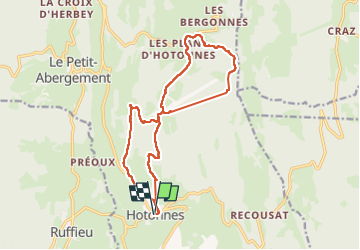

Length
15.9 km

Max alt
1202 m

Uphill gradient
576 m
Km-Effort
24 km

Min alt
739 m

Downhill gradient
577 m
Boucle
Yes
Creation date :
2025-03-16 07:53:50.0
Updated on :
2025-03-16 14:21:25.956
3h41
Difficulty : Very difficult

FREE GPS app for hiking
 SityTrail
IGN / Geographical institutes
SityTrail Plus
The world is yours!
About
Trail Walking of 15.9 km to be discovered at Auvergne-Rhône-Alpes, Ain, Haut Valromey. This trail is proposed by jean52.
Positioning
Country:
France
Region :
Auvergne-Rhône-Alpes
Department/Province :
Ain
Municipality :
Haut Valromey
Location:
Unknown
Start:(Dec)
Start:(UTM)
708482 ; 5097280 (31T) N.
Comments